Buachaille Etive Mor Hike
Buachaille Etive Mor mountain has 2 Munros,
the 3,350ft, 1,022m Stob Dearg seen right, and
the 3,136ft, 956m Stob na Broige at the south
end of the range, with the two peaks in the
middle not Munros, 9 miles east of Glencoe village,
83 miles north of Glasgow.
The image right is from the A82 road looking
at the east side of Buachaille Etive Mor, one
of the top Mountain photos in Scotland. The
Mountain is too steep to hike from this side,
is normally hiked from the north side where
there is a car park about 2 miles further down
the road.
For Images on Mobile swipe right
Click On Map for area Attractions
Camping & Touring Parks in
area
The Mountain is easy found as it is next to
the main A82 road, 3 miles west of the Glencoe
Mountain Resort. The Glasgow to Fort William &
Skye bus passes here but the closest stop
is at the Glencoe Mountain Resort.
There is a single lane road named Glen Etive
that runs down the Glen on the east side giving
many more great photos of this Mountain and
others.
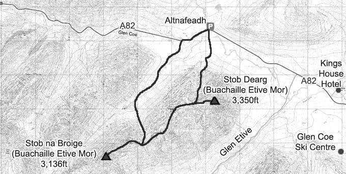
The car park named Altnafeadh for the hike
is right next to the main road, at about 880ft
/ 270m above sea level. This car park is a bit
rough, there is also a large Layby across the
road if you have a low car.
There is a narrow road that runs down from
the car park to a small Cottage named
Lagangarbh Hut. The Mountain is hard to photo
from this side as it is north facing, either
has to be early morning or in the evening.
The main hike Trail is past the Cottage, up
the Gully, up the Scree in the Gully, up a Step
Trail to the top of the Gully, then left to the
Summit. This is a fairly tough hike with loose
rock in parts.
Once on the north Summit named Stob Dearg,
you will see the south Summit named Stob na
Broige with two Sub Peaks between them.
Many people just hike to the north Summit
then back down the same way, others go down the
four peaks, then follow a steep path down the
west side, then walk up the Valley to the car
park.
There may be Ice and Snow in the Gully from
November to May as the Gully is north facing,
rarely gets the sun.
This Hike will average about 4 and a half
hours to the north peak and back, about 7 hours
if you do the whole range, add time on if you
like a few breaks.
Make sure and take an Ordnance Survey Map
and Compass on these hikes, and know how to use
them, as in cloud, these mountains can be
deadly. In Winter, make sure you have Crampons
and an Ice Axe, and know how to use them.
The Glencoe Ski Resort has
Glamping Pods, Touring Bays and Camping.
Large OS Map .
14 Large
Images
All Our Mountain
Tours
|
