|
The 729m / 2,392ft Ben Venue mountain is
situated at Loch Achray and Loch
Katrine, between Aberfoyle and Callander, at
the A821 tourist road, 31 miles north of
Glasgow.
There is a small Bus that runs
between Callander and Aberfoyle with stops at
Ben Venue mountain and Loch Katrine.
This is a Long Hike with a good Path and
Trail most the way to the top, with one Wet
Section about 100 yards just above scenic
Waterfalls, and a little bit of fairly safe
Scrambling at the Waterfalls, averaging 3 hours
up and 2 hour back down, about 4 and a half
miles to the top. The Car Park is about 300ft
above Sea Level.
For Images on Mobile swipe right
Click On Map for area
Attractions
Camping & Touring Parks in
area
Large OS
Map
The image Top is from the road from
Aberfoyle looking to Ben Venue.
The second image is of the Ben Venue Car
Park at the head of Loch Achray, about £5
per day in 2026, pay by Coins or Card.
Two Paths leave this Car Park, best use the
one on the left out through the Woodland where
you soon reach a Wooden Walkway with views to
Ben Venue.
From here you have to follow a number of
signs, down a single lane road, over a wooden
bridge, round a forest road, up a steep forest
path, up a forest road, then up another forest
path out onto the Mountain, all well sign
posted, just as well.
Once out onto the Mountain, follow a good
Path all the way around to Waterfalls on the
North Side, where the Path ends and a Trail
starts, you are then on the best Hiking Trail
in the Trossachs, nice and rugged.
There is a Steep Trail up past the
Waterfalls, with a little bit of fairly safe
Scrambling over Rocks.
Above the Waterfalls is a Wet Section about
100 yards to get through, or try and go round,
not doubt there will be a stone path laid here
some time.
The Trail then leads from the Wet Section up
to a Large Cairn.
At the Large Cairn, go up the real Steep
Trail to the right, some Hike up this, some
Scramble up it.
Above the Steep Trail is another Steep
Section.
You then see the Two Summits on Ben Venue,
most people go straight for the South Summit
with the Trig Point on it, a real good Steep
Trail up through Rocks, sometimes past Mountain
Goats.
Once at the Trig Point, the views down over
Loch Katrine, Loch Achray, and southeast to
Callander are probably the best views in the
Trossachs. Large Image
Loch Katrine has Boat Trips, Bike Hire and a
Diner.
Looking over to the North Top, it looks
higher, which it is, so most people follow the
Faint Trail over to that top on the way back
down. Large Image
Down off the North Side of the North Top is
steep but safe, taking you back onto the Main
Trail.
Going back down the Steep Section to the
Large Cairn, you will see two Mountains over to
the north, the 684m / 2,224ft Stob an Lochan,
and 579m / 1,900ft Beinn Bhreac with a Rocky
looking Ridge, they look a great Hike as well
from this side, most people Hike them from Loch
Ard though. Large Image
Back down past the Waterfalls shows it is a
long way back to the Car Park.
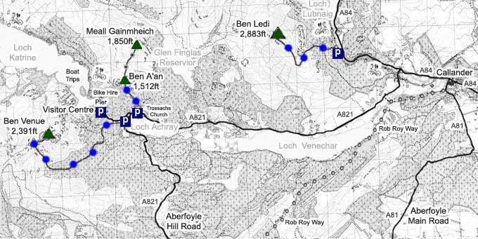
The Click on Map below shows the Tourist
Trails in Blue, Brown Rougher Trails.
Make sure and take an Ordnance Survey Map
and Compass on these Hikes, and know how to use
them, as in Cloud, these Mountains can be
deadly. In Winter, make sure you have Crampons
and an Ice Axe, and know how to use them.
Some people are now trying out OS Phone Apps
that can help.
|