|
The 3,002ft / 915m Ben Vane mountain is
situated on the west side of Loch Lomond by
Inveruglas Visitor Centre, 4 miles
north of Tarbet, 44 miles northwest of
Glasgow.
This is a Steep Hike averaging 3 hours up
and 2 back down, Visitor Centre Car Park is
about 30 feet above Sea Level, with a good
Trail all the way, with a couple of Fairly Safe
Scrambling Sections.
For Images on Mobile swipe right
Click On Map for area
Attractions
Camping & Touring Parks in
area
Large Hiking OS
Map
The image top is of the Inveruglas Visitor
Centre Car Park. It cost £3 per day
here in 2021, pay by Coins.
The Way to Ben Vane is to follow the
Roadside Path along past the Hydro Electic
Power Station here towards a Railway
Bridge.
Go up the Hill Road under the Railway Bridge
with the Hill Road taking you to the Base of
Ben Vane, about a 1 mile steady uphill
walk.
At the Base of Ben Vane, you will see a Road
lead off to the left over a Bridge, go along
that road till you Cross a Real Small Bridge,
from there you will see a good Man Made Path up
to Ben Vane.
This Path was laid around 2015? over what
used to be a Real Wet Section.
You soon reach the Steep South Side of Ben
Vane, at about 700ft above sea level, so about
2,300ft / 700m of real steep Hiking.
The First Steep Section takes you up to a
Viewpoint for great views over Loch Sloy Dam.
This is the only place where there is a Trail
over a High Drop, but is safe, just gives you a
sense of height.
The Mid Section has a good Little Scrambling
Section.
The Top Section has a Tougher Scrambling
Section, but still fairly safe.
Just above the Top Scrambling section is a
Short Trail to the Summit that you can Hike up,
but if you follow a Trail leading over to the
Left, you will have to Scramble over a Sloping
Rock that is not easy. Large
Image.
Ben Vane has a large Summit with Two Cairns,
from the East Side Cairn you get a View all the
way back down to Loch Lomond.
Large Image
Down to Loch Lomond.
Large Image
West to the Arrochar Mountains.
Back Down is the Same Trail.
Some people Hike the 3,093ft / 943m Ben
Vorlich on the same day, but it is 2,300ft /
700m back up to that Mountain Summit, making it
about 5,300ft / 1,615m of Steep Hiking in the
one day.
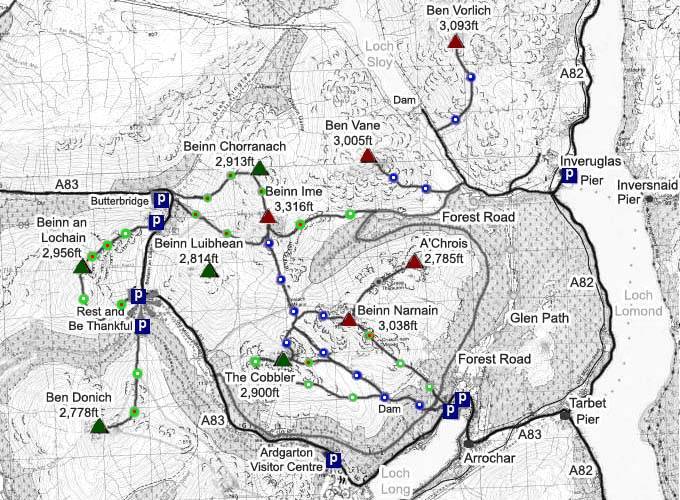
The Click on Map below shows the Tourist
Trails in Blue, Brown Rougher Trails, and Red a
Bit Dangerous.
Make sure and take an Ordnance Survey Map
and Compass on these Hikes, and know how to use
them, as in Cloud, these Mountains can be
deadly. In Winter, make sure you have Crampons
and an Ice Axe, and know how to use them.
Some people are now trying out OS Phone Apps
that can help.
|