|
The 2,956ft / 901m Beinn an Lochain mountain
is at the Rest and Be Thankful, 50 miles
northwest of Glasgow, 8 miles west of Tarbet at Loch
Lomond, on the A83 Road up to Arrochar and
Inveraray. Regular Buses run between
Glasgow and Inveraray stopping at the Rest and
be Thankful.
This used to be a Munro over 3,000ft, but
has since had its height dropped by more
accurate measurements. The Rest and be Thankful
is about 800ft above sea level, so this hike is
about 2,100ft from the car parks. There are two
Real Steep Sections with a little bit of
Danger, but fairly safe in Summer when no Ice.
Spikes and Ice Axe may be needed from October
to April.
For Images on Mobile swipe right
Click On Map for area
Attractions
Camping & Touring Parks in
area
The Image top is from the A83 Road towards
Beinn an Lochain Mountain. The Rest and Be
Thankful Viewing Area with a Car Park and Snack
Bar is at the bottom of the Mountain. This is
the part of the Road where there are land
slips, so Traffic Lights are here much of the
time. Large Image
with paths.
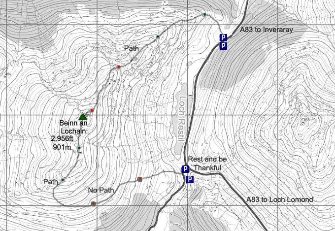
The second image is of the Car Park under 1
mile round from the Rest and Be Thankful, at
the start of the Trail up Beinn an Lochain from
the north. This is real steep in places, so
best go up this way, I avoided coming back down
this way.
You leave the Car Park, cross a narrow Burn
by Stepping Stones, then within 200 yards, you
are heading up the steep Rocky Path.
The First Steep Section is a good warm up
for further up.
The Second Steep Section has a bit of a
Dangerous Cross Path where there can be Ice
from about October to April, right above a high
drop, certainly tests your nerve if you are not
used to dangerous Mountains. Spikes and an Axe
will be needed in Winter. Large
Image.
The Top Steep Section has a good Trail up
just left of the Ridge, fairly safe, again
though tests your nerve if not used to real
steep hikes with high drops. Large Image.
I got up the two Steepest Sections with
Hiking Poles, just a few times had to throw
them up and use my hands to pull up. Large Image
back down from the top of the final steep
section.
Once up the Top Section, you realize you
have Twin Summits, but easy and safe to hike
between them with great views all around.
Large Image
west to Inveraray.
Large Image
east to the Rest and be Thankful and Arrochar
Mountains with heights.
Back Down is a lot easier down the South
Side, then once past the rocks, swing down onto
the East Side then make your way steadily down
the East Side back to the Rest and be
Thankful.
Back along the East Side has no Trail, but
fairly good going, just a few little Gorges to
cross.
Don't go down to fast, as the lower part is
soggy. Once back close to the Rest and be
Thankful, take the shortest route down through
the Soggy Lower Section to the Road a few
hundred yards along from the Rest and be
Thankful.
It is an easy walk from the Rest and be
Thankful down to the north side Car Park, you
can walk on the Loch Side of the Road Barrier
much of the way.
This is a cracking Hike if you want to try
Real Steep Sections with a little bit of
Danger, lets you know if you would fancy trying
some of the more Dangerous Ridges at Glencoe
and Fort William.
This is about as steep and dangerous as I
like it to get, I avoid anything with real
danger, just like a good hike with views.
Make sure and take an Ordnance Survey Map
and Compass on these Hikes, and know how to use
them, as in Cloud, these Mountains can be
deadly. In Winter, make sure you have Crampons
and an Ice Axe, and know how to use them.
Some people are now trying out OS Phone Apps
that can help.
|
