|
The image 2nd top is of the Ben Aan Car Park
and Start of the Path across the Main Road.
Cost £3 per day in 2021, pay by Coins or
Card.
This Car Park is often Full at Weekends /
Holidays. There is another Car Park a few
hundred yards north at the end of Loch Achray
for the Hike to the 729m /2,392ft Ben
Venue, there is often more space there.
The First Section up Ben Aan is fairly
steep, winding up over a Hiking Bridge.
The Second Section is a nice steady Walk
towards the Top Section. The Trees here were
cut down about 2016, should take a few years
before the new Trees block the view.
The Top Section looks impossible, but there
is a Real Steep Trail up through the Trees that
takes you onto the East Side.
The last 100ft up the East Side is fairly
steep, up to the pointy Summit of Ben Aan.
The Summit of Ben Aan is real popular for
Photos with Loch Katrine down to the left.
Large Image
You may see Tour Boats going up and Down
Loch Katrine, or people Biking along the east
side of the Loch, there is also a good Diner at
Loch Katrine with great views.
There are other Hills you can Hike to the
east of Ben Aan, but there are no real Trails
to them, so a bit testing through the Heather.
Large Image
Back down is the same Trail, the image right
shows just how steep it is. Large Image
This is a great little Mountain to try out
before taking on any over 3,000ft, is just as
steep, just half the height.
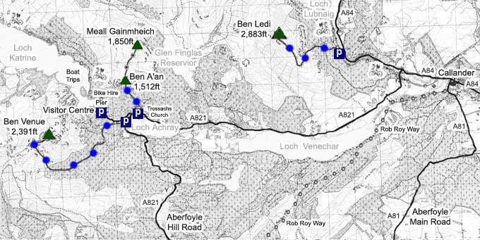
The Click on Map below shows the Tourist
Trails in Blue, Brown Rougher Trails.
Make sure and take an Ordnance Survey Map
and Compass on these Hikes, and know how to use
them, as in Cloud, these Mountains can be
deadly. In Winter, make sure you have Crampons
and an Ice Axe, and know how to use them.
Some people are now trying out OS Phone Apps
that can help.
|